A Trimble S7 total station set up on the west side of a Lubbock cut, tracking prisms mounted to soldier pile walls every 15 minutes—that’s how we start most mornings on a deep dig in Lubbock County. The focus is not just on the numbers scrolling across the data collector screen, but on what they mean for the stiff, sometimes heavily fissured clays of the Blackwater Draw Formation that sit beneath much of the city. With the population approaching 265,000 and the Texas Tech campus constantly pushing vertical expansion into tight urban lots, monitoring excavation behavior is a full-time engineering concern, not a periodic check. We run real-time deformation arrays that integrate with project BIM models so the structural engineer can see wall drift before it becomes a problem, coupling the surface data with in-place inclinometers that detect deep-seated movement at the toe of the shoring system. When the summer heat hits 100°F and the top three feet of clay shrink and crack, the behavior of a braced cut changes overnight, and a slope stability assessment that does not account for desiccation crusts can miss a failure plane by a wide margin.
A piezometer reading that rises instead of falling during dewatering tells you more about the excavation’s stability than a dozen visual inspections.
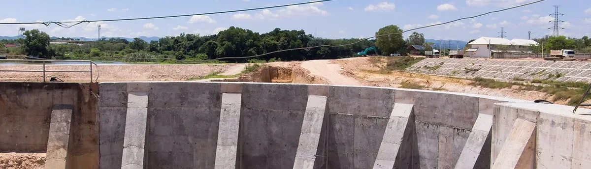
Our approach and scope
Lubbock’s expansion during the post-war boom of the 1950s and the subsequent growth of the medical district fundamentally changed how the city builds underground—parking garages, utility vaults, and basement-level research spaces now require cuts that penetrate 20 to 35 feet into the Pleistocene lacustrine deposits that define the Llano Estacado subsurface. These soils are not uniform: you can drill one boring and hit stiff tan clay with SPT N-values above 20, then move thirty feet laterally and encounter a lens of saturated silty sand that will ravel the moment the excavator bucket exposes it. That heterogeneity is why our instrumentation plans for Lubbock projects always include a combination of vibrating wire piezometers to track pore pressure dissipation and crackmeters spanning the ground behind the wall, because tension cracks propagating backward from the excavation face are the earliest warning of impending block failure in overconsolidated clays. We calibrate every inclinometer casing to a baseline reading taken after the guide casing is grouted and before any excavation begins, following the procedures outlined in ASTM D6230 for monitoring horizontal displacement, because even a half-inch drift at the bottom of a casing can indicate a rotational failure developing in the retained soil mass. The data stream from these instruments feeds into cloud-based dashboards that the superintendent can pull up on a tablet, with automated SMS alerts if the deflection rate exceeds 0.25 inches per day—a threshold we have found to be a reliable predictor of distress in Lubbock’s stiff fissured clays.
Local ground factors
The semi-arid climate of the South Plains creates a risk profile that differs sharply from what you would expect in Houston or Dallas: Lubbock averages only about 19 inches of rainfall annually, but when a thunderstorm cell parks over the excavation site and drops two inches in an hour, the desiccated surface clays cannot absorb the water fast enough, and runoff cascades into the cut, saturating the bench and triggering localized sloughing that can undermine the shoring system’s reaction points. That flash-flood scenario is why we insist on temporary berm drainage and pump sumps even on supposedly dry sites—the cost of a flooded excavation is not just the dewatering bill, but the week of lost monitoring data while inclinometer casings are checked for silt infiltration and the total station control points are re-surveyed after the storm disturbs the tripod setups. Equally important is the freeze-thaw cycling that hits the Caprock from November through February, when overnight lows drop below 25°F and then rebound to 55°F by afternoon; the thermal expansion and contraction of steel struts and walers can produce apparent wall movements of 0.10 to 0.15 inches that are purely elastic, but without temperature-compensated instrumentation logs, those movements get misread as soil creep, leading to unnecessary re-shoring work and project delays that cascade into the concrete pour schedule.
Reference standards
ASCE 7-22 – Minimum Design Loads for Buildings and Other Structures, IBC 2021 – Chapter 33, Safeguards During Construction, OSHA 29 CFR 1926 Subpart P – Excavations, ASTM D6230 – Standard Practice for Monitoring Horizontal Displacement Using Inclinometers, ASTM D7299 – Standard Practice for Verifying Performance of Inclinometers
Common questions
What does a typical excavation monitoring plan for a Lubbock site cost?
For a braced excavation 20 to 30 feet deep in the Lubbock area, a comprehensive monitoring package including two inclinometer casings, three vibrating wire piezometers, and automated total station tracking runs between US$920 and US$2,420, with the final figure depending on the cut length, the number of monitoring points, and the project duration. Short-term monitoring for utility trench excavations falls at the lower end, while multi-month instrumentation for parking garage cuts with real-time dashboards reaches the upper range.
How often should inclinometer readings be taken during active excavation in Lubbock’s clays?
During active excavation and shoring installation, we recommend inclinometer readings every 24 to 48 hours, increasing to twice-daily if the cut depth exceeds 25 feet or if a piezometer indicates rising pore pressure behind the wall. Once the excavation reaches final grade and the wall has stabilized, the frequency can drop to weekly readings, but we maintain continuous automated total station tracking on the wall face throughout the entire construction period.
What are the warning signs that a Lubbock excavation is becoming unstable?
The earliest indicators are tension cracks appearing in the ground surface behind the wall, particularly if they run parallel to the excavation and extend more than three feet back from the edge. Instrumentation-wise, a cumulative horizontal displacement exceeding 1.5 inches at the inclinometer, a piezometer reading that rises instead of falling during dewatering, or a crackmeter showing progressive opening beyond 0.25 inches all trigger immediate review. In Lubbock’s fissured clays, block failures can develop with very little visible warning, which is why we rely on instrumentation trends rather than visual inspection alone.
Do you install monitoring equipment before or after the shoring system is in place?
We install inclinometer casings and piezometers after the shoring wall guide trench is excavated but before the soldier piles or sheet piles are driven, so the instruments are in the undisturbed soil mass behind the wall. The baseline survey is completed 48 to 72 hours before excavation begins, giving the grout around the inclinometer casing time to cure and the piezometer time to equilibrate to ambient groundwater conditions. Installing instruments after the wall is in place risks damaging the casing during drilling and misses the initial stress relief movements that are often the most instructive part of the deformation curve.
How does Lubbock’s freeze-thaw cycling affect excavation monitoring readings?
Thermal expansion and contraction of steel shoring components during Lubbock’s winter temperature swings—where overnight lows can dip below 25°F and afternoon highs reach 55°F—produce apparent wall movements of 0.10 to 0.15 inches that are purely elastic. We compensate for this by recording ambient temperature at each monitoring interval and applying a correction factor to the displacement data, separating thermal effects from genuine soil-induced deformation. Without this correction, the monitoring record can show misleading drift that triggers unnecessary re-shoring work.